Ships navigating in coastal waters face challenges that are attributable to local weather conditions, tides and waves, and to the design of the ship itself. Before entering or leaving a tidal port, its daily change of tides needs to be precisely calculated for ship safety. Complying ship manoeuvering with predicted duration and Range of tide may be challenging for a ship on a particular voyage, which can also affect the port choice of shippers. If a ports tidal window is missed and restrictions are placed for shallow water navigation, it could delay a ship itinerary as much as up to 12 hours in waiting for the next tide to enter or depart from a port. This delay could also ripple through the ships long-term sailing schedule if on a liner service, affecting other ports of call. It is not a good choice for ship operators. A prudent navigator, therefore, needs to understand all tide terms before proceeding to a tidal port. We have summarized below some key abbreviations with a diagram for a better understanding.
In most parts of the world, tidal change occurs twice a day. The tide rises until it reaches its
a maximum level called high water or high tide and then falls to a minimum level
called low water or low tide.
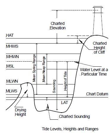
Chart datum or sounding datum is the level to which soundings and drying
heights on the chart, and heights in the tide tables are referred to. The chart
datum is generally referred to MLWS. In some parts of the world, it is the level of
the lowest astronomical tide (LAT). Under average meteorological conditions and
any combination of astronomical conditions, this is the lowest level to which tides
can be expected to fall. Due to changes in sea level, chart datum is subject to reexamination
from time to time.
A long period of observation for tides is 18.6 years, though some administrations
use 19 years.
Mean Sea Level (MSL) is the average level of the sea surface over a long period or the average level, which would exit without tides.
Charted depth is the actual depth of water at a place without applying the height of
tide and is the vertical distance downwards from chart datum to the seabed.
Drying height is the vertical distance from chart datum upwards to any surface
having a vertical height between chart datum and MHWS.
Height of Objects on the metric charts is measured in meters above MHWS.
Examples of such heights include the height of focal plane of a lighthouse,
mountains, towers, clearance under bridges, clearance under overhead cables,
and any other spot height of significance to the navigator.
Height of tide is the height of water above chart datum at any given instant.
The depth of water is equal to the charted depth plus the height of the tide.
A spring tide occurs when the moon is new or full, i.e., the moon is in conjunction with
sun and earth or opposition with sun and earth.
Neap tide occurs twice every month when the moon is at the first or third quarter,
i.e., it is in quadrature with sun and earth.
Some high water spring tides are higher than the others. Mean High Water
Springs (MHWS) is the average value for high water springs found by taking the
two consecutive highest tides each fortnightly tide cycle over a long period or
taken over a whole year when the average declination of the moon is 23 ½º.
Some high water neap tides are lower than the others. Mean High Water Neaps
(MHWN) is the average value for high water neaps found by taking the two
consecutive lowest high water neap tides each fortnightly tide cycle over a long
period or taken over a whole year when the average declination of the moon is
23 ½º.
Some low water neap tides are higher than the others. Mean Low Water Neaps
(MLWN) is the average value for low water neaps found by taking the two
consecutive highest low water neap tides each fortnightly tide cycle over a long
period or taken over a whole year when the average declination of the moon is
23 ½º.
Some low water spring tides are lower than the others. Mean Low Water
Springs (MLWS) is the average value for low water springs found by taking the
two consecutive lowest tides each fortnightly tide cycle over a long period or
taken over a whole year when the average declination of the moon is 23 ½º.
Mean Higher High Water (MHHW) is the average height of the higher high
waters of each tidal day over a long period.
Mean Lower High Water (MLHW) is the average height of the lower of high
waters of each tidal day over a long period.
Mean Higher Low Water (MHLW) is the average height of the higher of low
waters of each tidal day over a long period.
Mean Lower Low Water (MLLW) is the average height of the lower low waters
of each tidal day over a long period.
Mean High Water (MHW) is the average height of all high waters over a long
period at a given place.
Mean Low Water (MLW) is the average height of all low waters over a long
period at a given place.
Mean Tidal Level (MTL) is the average of the heights of MHWS, MHWN, MLWN
and MLWS.
Range is the difference in height between consecutive high and low waters, i.e.,
between one high water and the next low water or between low water to the
next high water. The value of Range may change from tide to tide. Daily Range is
the Range experienced on any one day.
Spring Range is the Range of tide at the time of spring tides.
Neap Range is the Range of tide at the time of neap tides.
Mean Spring Range is the difference between MHWS and MLWS.
Mean Neap Range is the difference between MHWN and MLWN.
Mean High Water Interval (MHWI) is the mean time interval between the
Moons meridian passage over Greenwich and the time of next high water at the
place concerned.
Related Information
Ships trial- turning circle diameters
Ships manoeuvering-turning circle advices
Ships navigation -Factors Affecting Turning circle diameter
More info pages
- Ships motion at sea and required precautions
Ships are affected by movement in six degrees of freedom; rolling, pitching, heaving, swaying, surging and yawing. Of these, rolling, pitching and heaving generate the highest forces during heavy weather. Read more.....
- Stress and Stability Calculation ,draft , trim & free surface effect
The Master shall ensure that the conditions of stability, hull strength, draft and trim of the vessel at sea and on arrival / departure at / from port and during loading / unloading cargo, bunkering and water ballast exchange, have been worked out, to secure safety of the vessel. He shall confirm the safety of the vessel by proper GM, stress and other factors as being within appropriate Limits.Read more.....
- Passage planning requirement for safe navigation at sea
Before proceeding to sea, the Master shall carefully check the Passage Plan, made after receiving the voyage instruction from the Charterer or the Company. Read more.....
- Safe anchoring practice
Anchoring into "Deep water" which is defined depth of water is beyond 50 meter, must be carried out with "Walk-back Style, however, on the VLCC operation there exists such a big inertia, Master can treat with Walking-back style even in the anchorage where water depth less than 50m, if following conditions are to be forecasted.
Read more.....

For any comments or suggestions please Contact us
Site Use and Privacy - Read our privacy policy and site use information.
Terms and conditions of use
Shipsbusiness.com is merely an informational site about various aspects of ships operation,maintenance procedure, prevention of pollution and many safety guideline. The procedures explained here are only indicative, not exhaustive in nature and one must always be guided by practices of good seamanship. User feedback is important to update our database.For any comments or suggestions please Contact us
Copyright © www.shipsbusiness.com All rights reserved.